An editorial by Jerusalem Post editor-in-chief David Horovitz posits low expectations for success of the latest round of Israeli-Palestinian peace talks getting underway this week, based on Yassar Arafat's intransigence during the 2000 peace talks.
Even president Bill Clinton, knowledgeable, committed and widely trusted by both sides, proved unable to foster a workable arrangement for Jerusalem 10 years ago....
The collapse of Camp David in 2000, for instance, when Yasser Arafat chose to shatter the high expectations of many Israelis and Palestinians, and opted not to legitimize Israel, was followed by his fostering of the second intifada's terror war.
Is Horovitz's version of events, one commonly held on both sides of the Atlantic, really accurate?
Flash back to July a decade ago, when the media were reporting an expected peace agreement between Arafat and Israel's Ehud Barak, after a marathon two weeks at Camp David with a determined Clinton & Co. Arafat suddenly left Camp David. Since then, we've seen Dennis Ross/Clayton Swisher/Jimmy Carter/Bill Clinton and others debate what Arafat rejected, when, and why.
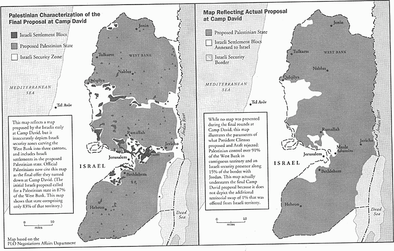
Hard to believe that even today, there are no 'official' maps available to the public showing what was offered/rejected by Arafat at Camp David. The closest we can get is a dramatic pair of maps on the website MidEastWeb.com, attributed to Clinton's chief negotiator, Dennis Ross, who says he had drawn up for his 2004 book, The Missing Peace. [Roughly similar maps are on the website of the Foundation for Middle East Peace.]
In a 2007 New York Times op-ed [where he criticizes Carter for using and mislabeling 'his' maps], Ross notes that the map on the left below "is actually taken from an Israeli map presented during the Camp David summit meeting in July 2000." The map on the right, he says, is "an approximation of what President Clinton subsequently proposed in December of that year."
These maps look radically different. On the left-hand map from July 2000 at Camp David, if what Ross wrote in the NYT is true, Palestine looks like three separate, non-contiguous entities surrounded by Israel - with Israel controlling the eastern border with Jordan. [Gaza, presumably a fourth entity, isn't shown on these maps.]

Is this very unattractive vision of a new nation, on the left, what Arafat thought he walked away from in July 2000?
Regarding the map on the right, which Ross says in the NYT is Clinton's December 2000 map: Arafat responded to what was obviously a much more attractive proposal, asking for more details, in a December 28, 2000 letter. Later the two sides talked at Taba, Egypt. Ross, in his book, says it was Arafat who ultimately wouldn't make a deal.
Yet even Ross seems confused. In his op-ed, he says they were offered many months apart - important months during which an epidemic of suicide bombers began, George Bush was elected president, and Ehud Barak was facing overwhelming right-wing opposition led by Ariel Sharon, who was indeed elected PM in February 2001. But in his book, Ross labels the maps as if both were offered at Camp David in summer 2000. Still, the one on the right says 'no map was presented.' Huh?
Could the confusion over maps help explain why Israelis continue to talk about the generosity of the offer their negotiators made to the ungrateful Arafat at Camp David, while Palestinians claim they were offered a bunch of bantustans?
A gross oversimplification, to be sure. But ....
Remembering the title of Ross's NYT op-ed, Don't Play with Maps, I hope today's negotiators are moving beyond this paper and pencil stuff anyway. In an era when Google Maps instantly displays the precise location of settlements, walls, "bypass" roads, and checkpoints - when folks on the Palestinian side sport American and British PhD's, not keffiyehs - why not sit down together over one huge digital map to negotiate?
Note to Mitchell's team: There's a great new interactive digital map on the S. Daniel Abraham Center for Middle East Peace's site, showing six different alternatives for the border between Israel and Palestine.
At least put your maps in Google docs, and hit the share button.