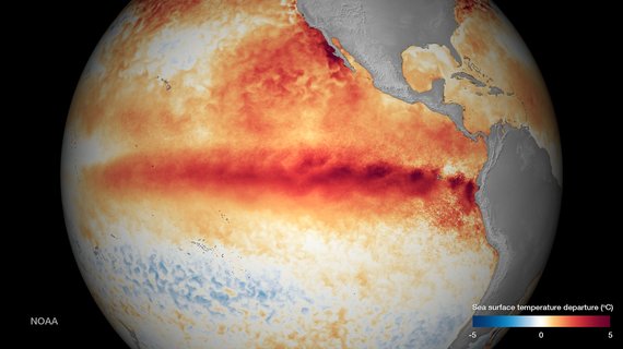
It's official: This El Niño is now the strongest in recorded history, as measured by the iconic sea surface temperature in the central eastern Pacific. The current weekly anomaly is 7% higher than the week prior, a reading that in turn had tied the high mark set by the '97 El Niño. That's a huge jump in one week. And the various tell-tale factors that scientists watch suggest only growth for this beast of an El Niño.
While unprecedented, this record setting El Niño is not wholly unexpected. For several years now the oceans have been swallowing and drawing down much of the heat that has been accumulating in the atmosphere, including the extra heat trapped in the atmosphere by the growing blanket of carbon pollution. That extra heat now appears to be reemerging with a vengeance.
Predicting how El Niños evolve in a warming planet is extremely challenging. The factors involved are far from being well understood. However, the most recent model projections tell us that we should expect extreme El Niños (and La Niñas) to happen more frequently. Records tend to be broken when natural variation runs in the same direction as climate change. And with this El Niño shooting along on a record-breaking path, we now may be seeing the effect of climate change happening in real time.
Predicting exactly what this El Niño will do to extreme weather in the United States is also challenging. We are now in uncharted territory. This El Niño is not only warmer where it counts, its effect appears to be reaching far north along the West Coast where it is helping to driving record breaking ocean temperatures. There are also other extremely odd features in the climate system this year that can throw a curve ball into predicting global weather patterns. A good example is the "the cold blob" in the north Atlantic that appears to be caused by ice water running off the melting Greenland ice sheet and in turn affecting ocean currents.
While charting the exact course of the extreme rains driven by this El Niño will be harder than ever before, it's not too difficult to foresee that those rains are likely to be charged with extra precipitation added by global warming. A warmer atmosphere holds more moisture. And just as a bigger bucket dumps more water when it empties, these El Niño rains are likely to hold and dump more water wherever they ultimately fall.
For many other areas of the world El Niño means drought. And here, too, climate change is likely to intensify the event, bringing hotter temperatures that dry out soils and melt snow packs. In California, the impact of higher temperatures on the state's critical Sierra Nevada snow pack might offset some of the hoped-for precipitation brought by El Niño. This last winter saw average overnight lows in the mountains rise above the freezing point for the first time.
From the Cold Blob to El Niño, the regional features of our climate system are becoming harder to predict due to climate change. We have been gambling with the weather, dramatically magnifying the risks we face from extreme events. Disaster usually strikes when a threshold is crossed. Our economic infrastructure has been built to withstand the historical extremes. Likewise natural ecosystems have evolved to adapt to those same extremes. When faced with new extremes these systems, natural and human alike, often collapse.
Going forward, we now have two tasks: we must work to avoid the worst of climate change and we must adapt to those changes we can no longer avoid. This winter should give us powerful look at that future.
