Satellite images of Nepal released on Tuesday show the sprawling tent cities in and around the capital of Kathmandu, where thousands are sheltering after Saturday's earthquake.
The before-and-after images released by Google Earth show the vast encampments that have sprung up in parks, stadiums and other open spaces in the wake of the disaster.
The Nepali government has set up 16 official camps to house the displaced, but many residents have set up their own makeshift shelters along the streets of the city. Hundreds of thousands are sleeping in the open, having lost their homes or feeling too afraid to return amid a wave of powerful aftershocks, according to the BBC.
Tundikhel, an important landmark in central Kathmandu, in November 2014, and on April 27, 2015.
“Every time we feel the earth shake, we’re even more scared to go back home,” housewife Surja Laxmi, 40, sheltering with her family in a Kathmandu courtyard, told The WorldPost on Monday.
At least 5,000 people have been confirmed dead in the 7.8-magnitude earthquake, which sent deadly tremors through neighboring countries and triggered a series of avalanches at Mount Everest. Nepali Prime Minister Sushil Koirala warned Tuesday that the death toll could rise to 10,000 as rescuers reach remote areas near the epicenter of the earthquake.
Guita Dumar, an open area in Patan, just south of Kathmandu, in December 2014 and on April, 27, 2015.
The Kasthamandap Temple in central Kathmandu, in November 2014 and on April 27, 2015.
A usually busy intersection by the Kalmochan Mahadev Temple, Kathmandu, in November 2014 and on April 27, 2015.
The south tip of Tribhuvan International Airport in Kathmandu, in December 2014 and on April 27, 2015.
A stadium and open lot in Lalitpur, south of Kathmandu, in December 2014 and on April 27, 2015.
The United Nations also released satellite images of several buildings and landmarks in the Nepali capital before and after the earthquake. The images were taken by satellite companies CNES and Distribution Airbus Defence and Space, with the after images captured on April 27, 2015.
Dharahara Tower, Kathmandu
BEFORE: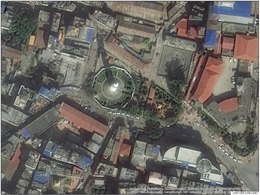
AFTER: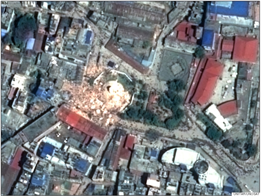
Hanuman Dhoka Durbar Square, Kathmandu
BEFORE: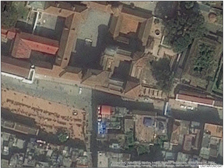
AFTER: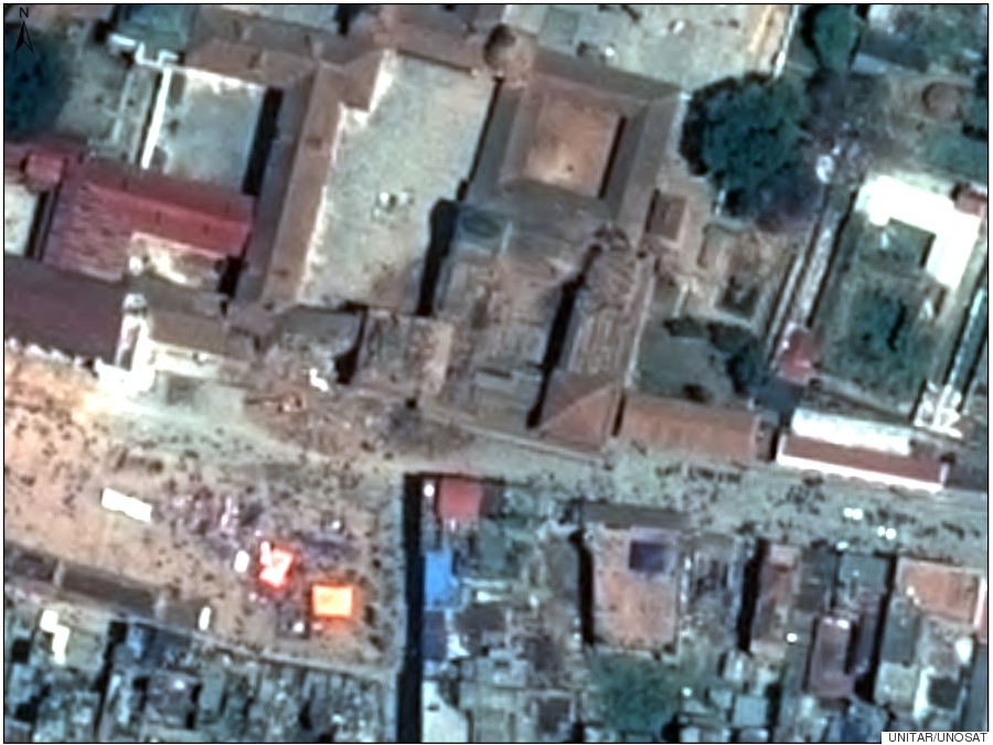
Collapsed building, Kathmandu
BEFORE: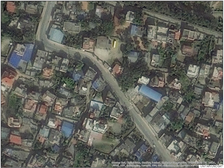
AFTER: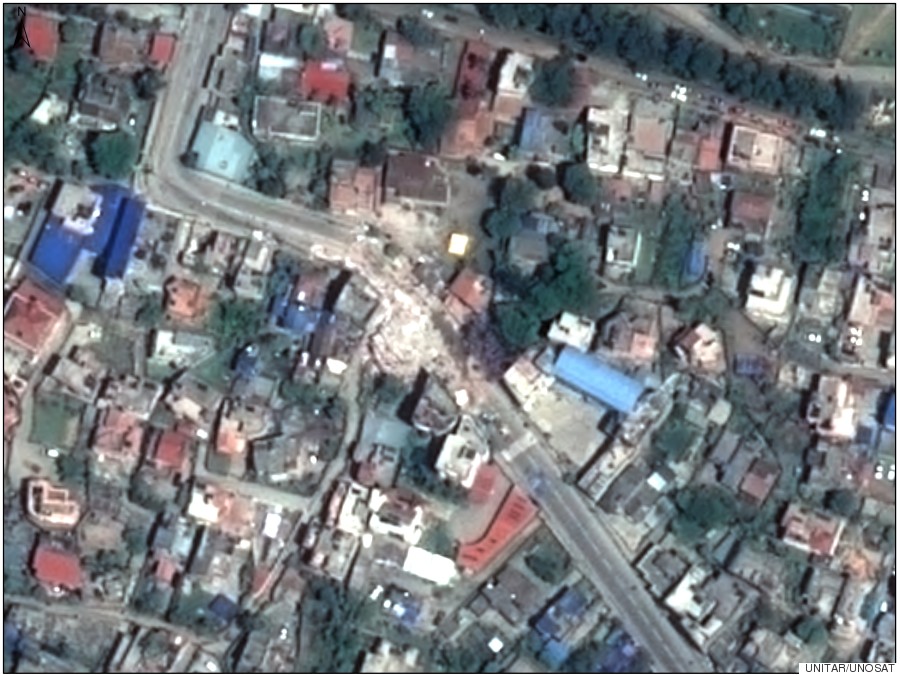
Support HuffPost
Our 2024 Coverage Needs You
Your Loyalty Means The World To Us
At HuffPost, we believe that everyone needs high-quality journalism, but we understand that not everyone can afford to pay for expensive news subscriptions. That is why we are committed to providing deeply reported, carefully fact-checked news that is freely accessible to everyone.
Whether you come to HuffPost for updates on the 2024 presidential race, hard-hitting investigations into critical issues facing our country today, or trending stories that make you laugh, we appreciate you. The truth is, news costs money to produce, and we are proud that we have never put our stories behind an expensive paywall.
Would you join us to help keep our stories free for all? Your contribution of as little as $2 will go a long way.
Can't afford to donate? Support HuffPost by creating a free account and log in while you read.
As Americans head to the polls in 2024, the very future of our country is at stake. At HuffPost, we believe that a free press is critical to creating well-informed voters. That's why our journalism is free for everyone, even though other newsrooms retreat behind expensive paywalls.
Our journalists will continue to cover the twists and turns during this historic presidential election. With your help, we'll bring you hard-hitting investigations, well-researched analysis and timely takes you can't find elsewhere. Reporting in this current political climate is a responsibility we do not take lightly, and we thank you for your support.
Contribute as little as $2 to keep our news free for all.
Can't afford to donate? Support HuffPost by creating a free account and log in while you read.
Dear HuffPost Reader
Thank you for your past contribution to HuffPost. We are sincerely grateful for readers like you who help us ensure that we can keep our journalism free for everyone.
The stakes are high this year, and our 2024 coverage could use continued support. Would you consider becoming a regular HuffPost contributor?
Dear HuffPost Reader
Thank you for your past contribution to HuffPost. We are sincerely grateful for readers like you who help us ensure that we can keep our journalism free for everyone.
The stakes are high this year, and our 2024 coverage could use continued support. If circumstances have changed since you last contributed, we hope you’ll consider contributing to HuffPost once more.
Already contributed? Log in to hide these messages.
