

The Himalayas
By Stacy Morford
Forty-year-old spy satellite images are beginning to provide the first consistent look at how glaciers across the Himalayas are changing and what future water supplies might look like for millions of people who rely on their seasonal melt.
Until now, knowledge about glacier mass change in the region has been spotty, with inconsistent measurements from glacier to glacier. Public satellite images could reveal changes in a glacier’s area but not its height or mass, so scientists made physical measurements by putting stakes in the ice and checking back year to year. Many glaciers are too remote or too dangerous to reach, though, making field data scarce.
When the U.S. government began declassifying spy satellite data, scientists figured out how to manually build 3D elevation models by matching landmarks between images and calculating the satellite camera’s angle, but the process was still time consuming and inconsistent.
Josh Maurer, a graduate student at Columbia University’s Lamont-Doherty Earth Observatory, developed a better way.

The Himalayas
Picture a stereoscope, like the View-Master with its cardboard reels of tiny photos. The stereoscope takes two photos of the same scene, shot from slightly different angles, and puts them together so your eyes see a 3D image through the viewer. Maurer took that concept and used computer vision techniques to design an automated process that creates consistent 3D models of glaciers across a wide region as they appeared in the past using declassified spy satellite images.
By automating the process, Maurer was able to start creating the first consistent look at glacier change over the past 40 years across Asia’s entire high-mountain region, from the greater Himalaya, including Bhutan and Nepal, through the Karakorum and into the Hindu Kush. This week, he is presenting his early results at the American Geophysical Union Fall Meeting in San Francisco.
“It can take years for a glacier to fully respond to a change in climate, so looking back several decades gives us a better signal,” Maurer said. “While we have volume changes over the last decade or so from more modern remote sensing platforms, glacier response times can be longer than that. The declassified spy satellite data allows for actual ice volume changes over those longer time scales.”
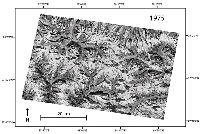
Maurer used declassified spy satellite data to create the above 3D interactive image of glaciers along the border between Nepal and Sikkim, India, as they existed in 1975. Click and drag on the image to rotate it.
Tapping into Hexagon
Creating a 3D image requires at least two overlapping photos of the glacier. Maurer found the overlap he needed in declassified material from a U.S. spy satellite program called Hexagon, which operated from 1971 to 1986.
During the Cold War, Hexagon’s 20 reconnaissance satellites orbited the planet, each capturing a series of images that could overlap by 55 or 70 percent. That overlap allowed for 3D vision that public satellite systems at the time, like the early Landsat program, couldn’t provide.
Knowing how glaciers are changing is critical for communities and governments across the region today as they plan for water changes in the future. Roughly 20 percent of the world’s population relies on the Himalayan glaciers’ seasonal meltwater, in addition to monsoonal rain and snowfall, for drinking water, to grow crops and to produce energy. Bhutan’s economy, for example, relies heavily on the production and sale of hydropower, and parts of India rely on that energy source to power their homes and businesses.
“Life depends on water, so changing the amount or timing of how that water reaches a community or an ecosystem is going to have an impact,” Maurer said.
The above 3D interactive image shows the same region between Nepal and Sikkim, India, as above, but shows it as it existed in 2007. Maurer created it using data collected by NASA’s Terra satellite in 2007.
Lessons from Bhutan
Maurer’s work has already revealed insights into how differently the Himalayas’ glaciers can behave.
He and his co-authors from Lamont, the University of Utah, and Brigham Young University, where Maurer started work on the project as a Master’s student, published their first results this summer covering 21 glaciers in just the Bhutan region. They compared the Hexagon images from 1974 with images taken in 2006 by the ASTER imaging instrument aboard NASA’s Terra satellite.
The scientists found that the Bhutan glaciers have been losing more ice than they have been gaining. Their most conservative estimate for average mass loss, if melted to water, was be equivalent to nearly 7 inches lost over the entire surface of each glacier every year.
A comparison of images taken in 1975 and 2007 of the same region along the border between Nepal and Sikkim, India, reveal changes in the elevation of the region’s glaciers
That mass loss varied from glacier to glacier, though, and by the glaciers’ characteristics. The glaciers that ended in a glacial lake lost more ice per year than those that didn’t. Clean-ice glaciers, with surfaces directly exposed to the Sun’s radiation, lost only slightly more ice than glaciers that were covered with debris that could helped to insulate the ice from the sun’s rays; the reason debris-covered glaciers were vulnerable, Maurer found, appeared to be that ice cliffs and melt ponds were forming on those glaciers and enhancing the melting. One glacier was losing ice about twice as fast as the others for reasons that are still unclear.
The results show why a single glacier can’t be used as a benchmark for a region like Bhutan — there is too much variability. They also show that declassified spy satellite data can overcome that challenge by providing a consistent picture of a large area of the Earth.
Maurer’s tool is allowing scientists to quantify glacier change over space and time in a consistent way that hadn’t been done before, said University of Utah Professor Summer Rupper, who has conducted many expeditions to measure changing glacier mass. The arduous and often risky trips to high-mountain glaciers will still be necessary, though, she said.
“A glacier may be losing mass for two reasons — it may be from melt or it may be getting less snow,” Rupper said. “Remote sensing can give you the net change but not the cause. The power is when you can couple that with on the ground information to put that into perspective.”
Stacy Morford is a former AP reporter and science writer at Columbia University’s Lamont-Doherty Earth Observatory. This article is made available by Nexus Media, a syndicated newswire covering climate, energy, policy, art and culture.
